There are some great one day hikes within easy reach of the Swiss city of Geneva but some are easier than others, writes Monty Pierce Jones.
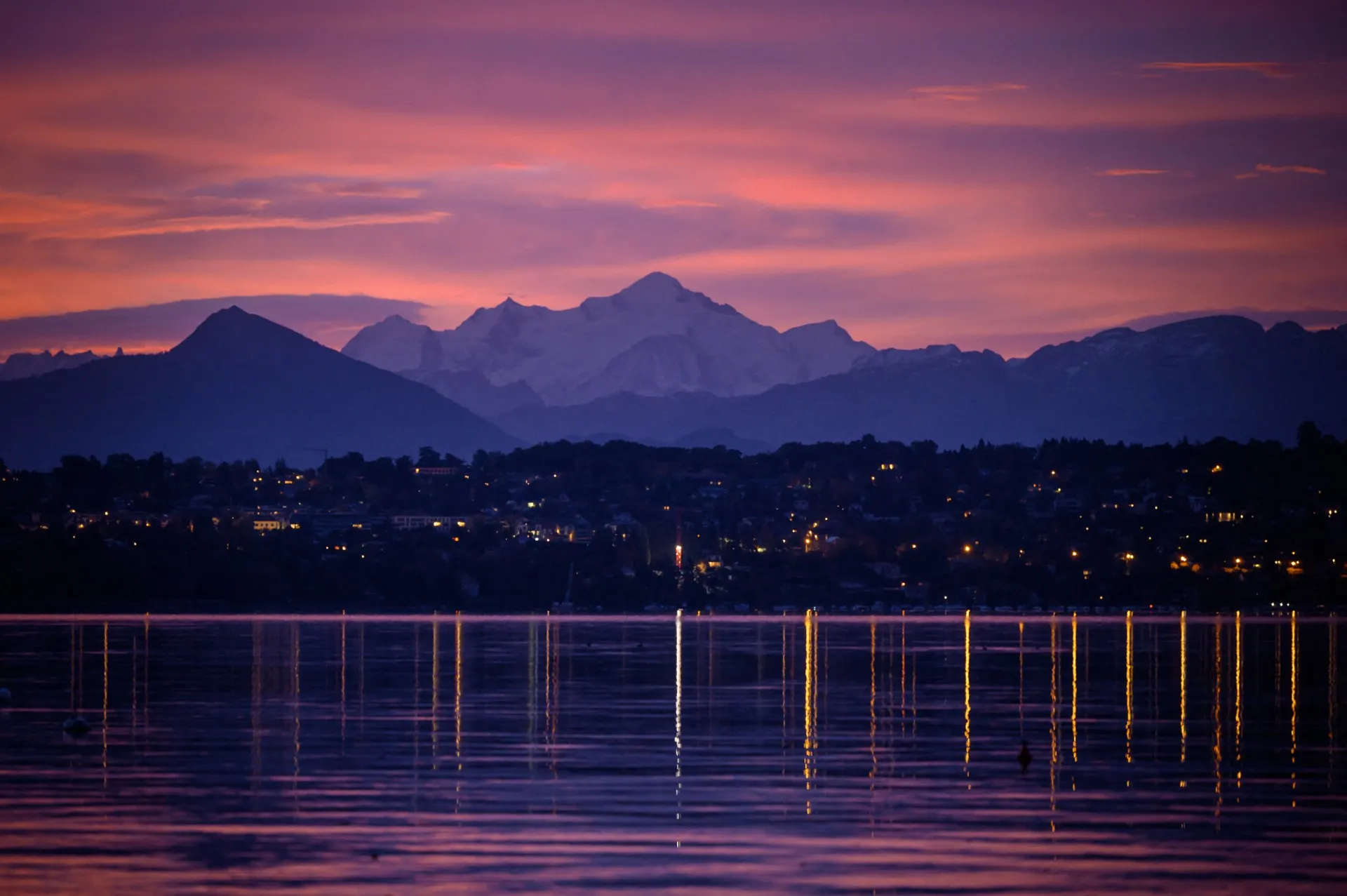
When you walk across the Pont du Mont Blanc in the centre of Geneva you notice that you can’t actually see Mont Blanc itself.
Instead, what catches your eye are a series of smaller, but no less iconic, mountains: Le Salève, Les Voirons, and Le Môle which make up the backdrop of Rive Gauche, and when looking the other way it is impossible to miss the Jura, with Crêt de la Neige and La Dôle being the more eye-catching summits of “Switzerland’s spine”.
These foothills hug the Geneva metropolitan area (forming la cuvette genevoise) – and other than trapping pollution, they offer some brilliant hiking for locals and visitors alike.
Here are 7 of the best.
Le Salève
The Salève, is known as the balcony of Geneva. The main backdrop of this Swiss city is found in… France, like almost every other hike on this list. It feels like a great limestone wave about to crash onto you: the “French side” builds up slowly to the abrupt cliffs, striations, and quarry of the “Genevois side”. Frankenstein’s monster scales this perpendicular face in Mary Shelley’s book.
I’m not suggesting you follow in Frankenstein’s footsteps exactly, but you too can climb the Salève. Here are two recommended routes:
Via Le Pas de l’Échelle
This four and half hour, 4.4km hike offers an easier walk – but it’s not to be underestimated. Le Pas de l’Échelle is the historic way up the hill, its carved stone step sections attest to its 14th century roots. Park at the Gare de Départ of the Téléphérique (15 minute drive from Geneva’s centre, 40 minutes with a walk if you take the 8 bus) and head towards Chemin du Bois Meriguet. After an hour or so you’ll pass through the lovely village of Monnetier nestled between the Petit and Grand Salève – before reaching the “Panorama”, where you might catch a few paragliders taking off.
#paragliding flight above the #saleve tonight. #lake #geneva #lacleman #mountain #montblanc #parapente #aerialphotography pic.twitter.com/hNY7rAWMN2
— YvesJusot (@YvesJusot) June 8, 2019
Via Chemin de la Grande Gorge
This is a more difficult hike – both longer and steeper than Le Pas de l’Échelle. As the name suggests, it follows the “big gorge” that cuts through this part of the Salève. It winds its way through the couloir before cutting left towards the “Panorama”. It is a more adventurous, secluded climb, and was apparently used by smugglers back in the day. Start from the same spots as Le Pas de l’Échelle.
Advertisement
You can go up one way and down the other to mix things up.
Get more info on trekking La Salève.
Le Signal des Voirons
Le Massif des Voirons (1,480 m) reaches higher than the more dramatic Salève (1,379 m) despite often being overshadowed by it.
This is an injustice, as getting to the top earns you the best 360 degree view on this list. Les Dents du Midi are viewable from the top. It is also wilder than Le Salève, so keep an eye out for orchids, chamois, and if you’re really lucky, a lynx.
C’est mon ancien balcon le Signal des Voirons pic.twitter.com/HBnXt0nyZK
— Jesus Browka (@JesusBrowka) July 9, 2017
Start from the Lac de Machilly parking (30 minutes by car) or the Machilly station (45 minutes by train via Annemasse) and head towards Chemin du Sauget. Turn right on Route du Seujet and you’ll find yourself at the signposted start of the five hour – 17 km loop of Les Voirons.
Advertisement
Le Môle
Le Môle sits further back from the city, but at 1,863 metres (the tallest mountain on this list) it is no molehill. In fact, it has one of the most recognisable silhouettes in the region: a near-perfect pyramid. It too was mentioned by Shelley in Frankenstein.
For an easy, sunny four hour – 9 km hike, drive 40 minutes to Saint-Jean-de-Tholome, park at Chez Beroud, and head towards the summit.
Advertisement
Petit Salève Loop
Park at the Château d’Etrembières (20 minute drive from the centre – can also take the 17 tram and walk). Head towards the forest and walk for around 2 hours hours. You will eventually reach the Camp des Allobroges near the summit. The Allobroges were the Celtic tribe that founded Geneva, they may even have helped Hannibal cross the Alps.
https://twitter.com/ClemSimonnet/status/1348289639321374720
The remnants of their hillfort (or oppidum) – placed there as a symbol of control – are probably the best thing about the hike. The 6km loop should take you about four hours. On the way up you’ll have great views of Geneva and the Jura, and on the way back of Mont Blanc and the Môle.
Chemin de La Dôle
This hike is the only one on this list that is wholly in Switzerland, funnily enough. La Dôle is known for the iconic weather dome that you can easily spot from Le Jardin Anglais.
The views from the summits of the other hikes on this list, as wonderful as they are, do cross-over a fair amount: you can spot Le Môle from Les Voirons and vice versa; they all have great views of Geneva and the Massif du Mont Blanc.
Le premier #PassionRando de la saison du côté de la Dôle, un peu trop de neige sur le chemin mais ce fut fort sympathique ! 🏔🏔 pic.twitter.com/vPxjjbmg88
— Willem || Psyko (@WDufal) April 20, 2018
La Dôle offers something different, you get a better sense of l’arc lémanique, and more expansive views of the alps (especially the Bernese and Chablais Alps). It is the furthest out from Geneva, at an hour by train or 45 minutes by car, but it’s worth it.
Le Chemin de La Dôle (SuisseMobile route 116) is a long but easy hike. You will likely walk 15km in 5 hours. You should start in La Givrine and end in St Cergue, though you can keep going to Nyon and in doing so complete the last stage of the Jura Crest Trail (SuisseMobile route 5).
Le Reculet + Crêt de la Neige
This is the hardest hike on this list, if you’re up to it you’ll reach the highest point in the Jura mountains. Le Reculet and Crêt de la Neige don’t jut out much from the Jura range but you can spot them from around the city. Next time you find yourself on one of the stops of the 12 tram in Rive Gauche, look up and you’ll realise that they are often framed by Geneva’s low-rise buildings.
Great view of #geneve from le reculet. That's some climb! pic.twitter.com/MdVIVcdG0E
— Ian Whittle (@IanWhittle2) August 6, 2017
It will take you 40 minutes by car to get to the trailhead (Tiocan, Thoiry), or 1h40 minutes by public transport (50 minutes to Thoiry – take the 18 tram and the 68 bus – and 50 minutes walk). Be prepared for a 13.5 km, 7 hour hike – and a view that encompasses every other peak on this list. It’s worth it.
Further reading:
The websites Monts de Geneve offers more info for treks in the area.
